
Rishikesh topographic map
Click on the map to display elevation.
Rishikesh
Rishikesh is at 30°06′12″N 78°17′41″E / 30.103368°N 78.294754°E / 30.103368; 78.294754. It has an average elevation of 372 metres (1,220 ft). The town is located in the Tehri Garhwal region of the northern Indian state of Uttarakhand.
About this map
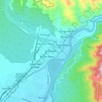
Name: Rishikesh topographic map, elevation, terrain.
Location: Rishikesh, Dehradun, Uttarakhand, 249201, India (30.06865 78.25162 30.14865 78.33162)
Average elevation: 497 m
Minimum elevation: 323 m
Maximum elevation: 1,363 m