Geolocate

Bharari topographic map

Click on the map to display elevation.

About this map

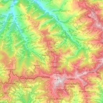
Name: Bharari topographic map, elevation, terrain.

Location: Bharari, Shimla, Himachal Pradesh, 171003, India (31.08377 77.13654 31.16377 77.21654)

Average elevation: 1,861 m

Minimum elevation: 1,252 m

Maximum elevation: 2,439 m

Gear up for your next adventure:

🦯Trekking Poles - Reduced impact on joints for steep topographic climbs
🔋Lithium AA Batteries - Long-lasting power that performs in extreme cold
🥾Hiking Leggings - Comfortable leggings for outdoor activities
🥾Approach Boots - Comfortable boots for hiking and climbing approaches
🦶Anti-Blister Balm - Prevents friction and hotspots during long ascents

As an Amazon Associate, this site earns from qualifying purchases at no extra cost to you.