
Make a donation
Gear up for your next adventure:
As an Amazon Associate, this site earns from qualifying purchases at no extra cost to you.
Tumakuru topographic map
Click on the map to display elevation.
Make a donation
Gear up for your next adventure:
As an Amazon Associate, this site earns from qualifying purchases at no extra cost to you.
Tumakuru
Tumkur (officially Tumakuru) is a city located in the southern part of Indian state of Karnataka. It is situated at a distance of 70 km (43 mi) northwest of Bangalore, the state's largest city and capital, along NH 48 and NH 73. It is the headquarters of the Tumakuru district. It is located at an altitude of 835 m (2739.5 ft).
Make a donation
Gear up for your next adventure:
As an Amazon Associate, this site earns from qualifying purchases at no extra cost to you.
About this map
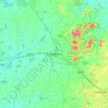
Name: Tumakuru topographic map, elevation, terrain.
Location: Tumakuru, Tumkur taluk, Tumakuru, Karnataka, 572101, India (13.18008 76.94062 13.50008 77.26062)
Average elevation: 838 m
Minimum elevation: 752 m
Maximum elevation: 1,243 m
Make a donation
Gear up for your next adventure:
As an Amazon Associate, this site earns from qualifying purchases at no extra cost to you.