Geolocate

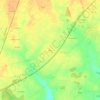
Courtalain topographic map

Click on the map to display elevation.

About this map

Name: Courtalain topographic map, elevation, terrain.

Location: Courtalain, Vald'Yerre, Châteaudun, Eure-et-Loir, Centre-Val de Loire, France métropolitaine, 28290, France (48.07327 1.12166 48.09224 1.15165)

Average elevation: 153 m

Minimum elevation: 130 m

Maximum elevation: 168 m

Other topographic maps

Click on a map to view its topography, its elevation and its terrain.
Plafus

France > Centre-Val de Loire > Eure-et-Loir > Vald'Yerre

Average elevation: 161 m

Gear up for your next adventure:

🛶Canoe Life Vest - Safety vest for water sports
🧊Portable Cooler - Keep food and drinks cold during outdoor adventures
🧥Thermal Fleece Jacket - Versatile insulation for changing mountain temperatures
🥾Mountain Hiking Boots - High-traction boots for rocky terrain
🔭Compact Monocular - One-handed bird watching and trail spotting

As an Amazon Associate, this site earns from qualifying purchases at no extra cost to you.