Geolocate

Waru topographic map

Click on the map to display elevation.

About this map

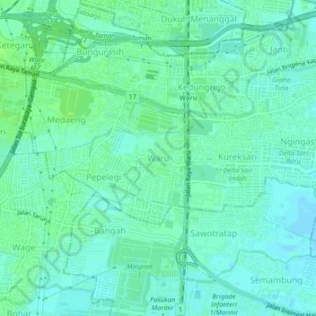
Name: Waru topographic map, elevation, terrain.

Location: Waru, Sidoarjo, East Java, Java, 61256, Indonesia (-7.38139 112.70559 -7.34139 112.74559)

Average elevation: 5 m

Minimum elevation: 1 m

Maximum elevation: 10 m

Other topographic maps

Click on a map to view its topography, its elevation and its terrain.

Sedati

Indonesia > East Java > Sidoarjo

Average elevation: 1 m

Candi

Indonesia > East Java > Sidoarjo

Average elevation: 3 m

Tarik

Indonesia > East Java > Sidoarjo

Average elevation: 18 m

Balongbendo

Indonesia > East Java > Sidoarjo

Average elevation: 21 m

Wonoayu

Indonesia > East Java > Sidoarjo

Average elevation: 10 m

Porong

Indonesia > East Java > Sidoarjo

Average elevation: 22 m

Sukodono

Indonesia > East Java > Sidoarjo

Average elevation: 8 m

Jabon

Indonesia > East Java > Sidoarjo

Average elevation: 4 m

Gear up for your next adventure:

💡LED Camping Lantern - Illuminate your campsite with long-lasting lanterns
🔭Outdoor Binoculars - Lightweight binoculars for birdwatching and hiking
🥾Trekking Poles - Adjustable trekking poles to reduce knee stress and improve stability
🥾Hiking Gaiters - Protect legs and shoes from mud, snow, and debris
👟Trail Running Shoes - Agile footwear for fast-paced topographic exploration

As an Amazon Associate, this site earns from qualifying purchases at no extra cost to you.