Geolocate

Carnota topographic map

Click on the map to display elevation.

About this map

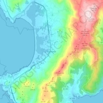
Name: Carnota topographic map, elevation, terrain.

Location: Carnota, Muros, Galicia, 15293, Spain (42.78196 -9.12780 42.86196 -9.04780)

Average elevation: 146 m

Minimum elevation: -4 m

Maximum elevation: 581 m

Gear up for your next adventure:

🔦LED Headtorch - Bright and durable light for night activities
🧊Insulated Water Bottle - Keeps drinks cold in summer and prevents freezing in winter
🧢Outdoor Visor - Breathable visor for sunny hikes
🧢Outdoor Cap - Protective cap for sun and rain during hikes
🧭GPS Outdoor Watch - Smart watch for navigation and fitness tracking in nature

As an Amazon Associate, this site earns from qualifying purchases at no extra cost to you.