Geolocate

Lutsk topographic map

Click on the map to display elevation.

About this map

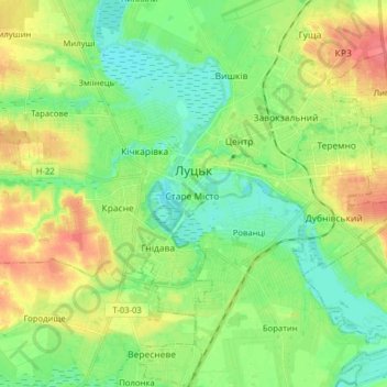
Name: Lutsk topographic map, elevation, terrain.

Location: Lutsk, Lutsk Urban Hromada, Lutsk Raion, Volyn Oblast, Ukraine (50.68900 25.26196 50.78888 25.40580)

Average elevation: 195 m

Minimum elevation: 173 m

Maximum elevation: 229 m

Other topographic maps

Click on a map to view its topography, its elevation and its terrain.

Zaluzhne

Ukraine > Volyn Oblast

Average elevation: 222 m

Prypiat River

Ukraine > Volyn Oblast

Average elevation: 142 m

Mala Hlusha

Ukraine > Volyn Oblast

Average elevation: 151 m

Kulchyn

Ukraine > Volyn Oblast

Average elevation: 183 m

Prypiat River

Ukraine > Volyn Oblast

Average elevation: 142 m

Pishchane

Ukraine > Volyn Oblast

Average elevation: 166 m

Prypiat River

Ukraine > Volyn Oblast

Average elevation: 142 m

Prypiat River

Ukraine > Volyn Oblast

Average elevation: 142 m

Zavitne

Ukraine > Volyn Oblast

Average elevation: 191 m

Gear up for your next adventure:

🧭GPS Outdoor Watch - Smart watch for navigation and fitness tracking in nature
🥾Trail Hiking Socks - Comfortable socks to prevent blisters and fatigue
🧣Evaporative Cooling Towel - Beat the heat during intense summer climbs
🔦LED Flashlight - Powerful and long-lasting flashlight for camping and emergencies
🧰Emergency Multi-Tool - Compact multi-tool for outdoor survival

As an Amazon Associate, this site earns from qualifying purchases at no extra cost to you.