Geolocate

Arrington topographic map

Click on the map to display elevation.

About this map

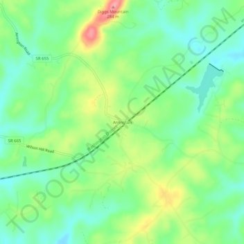
Name: Arrington topographic map, elevation, terrain.

Location: Arrington, Nelson County, Virginia, 22922, United States (37.66403 -78.92113 37.70403 -78.88113)

Average elevation: 207 m

Minimum elevation: 171 m

Maximum elevation: 271 m

Other topographic maps

Click on a map to view its topography, its elevation and its terrain.

Piney River

United States > Virginia > Nelson County

Average elevation: 266 m

Tye River

United States > Virginia > Nelson County

Average elevation: 251 m

Gear up for your next adventure:

🛶Kayak Accessories - Essential gear for safe and fun kayaking adventures
🥾Waterproof Hiking Boots - Boots keeping your feet dry in wet conditions
🧶550 Survival Paracord - Versatile utility cord for emergency repairs and rigging
🛌Down Sleeping Bag - Superior warmth-to-weight ratio for cold nights
🧴Insect Repellent - Protect yourself from bugs during outdoor adventures

As an Amazon Associate, this site earns from qualifying purchases at no extra cost to you.