
Medstead topographic map
Click on the map to display elevation.
Medstead
Medstead is a village and civil parish in the East Hampshire district of Hampshire, England. Its nearest town is Alton, which lies 4.3 miles (6.9 km) northeast of the village. According to the 2011 census, the village had a population of 2,036 people. The parish covers an area of 1,536 acres (622 ha) and has an average elevation of approximately 600 feet (180 m) above sea level. One of the county's high points at 716 feet (218 m), King's Hill, runs through Medstead and Bentworth.
About this map
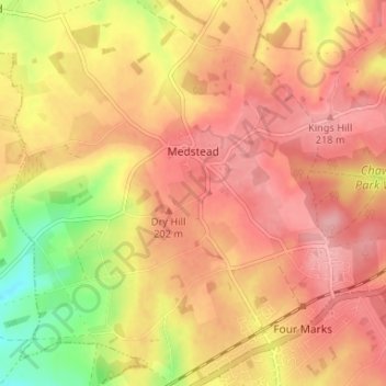
Name: Medstead topographic map, elevation, terrain.
Location: Medstead, East Hampshire, Hampshire, England, United Kingdom (51.10494 -1.09543 51.14600 -1.03704)
Average elevation: 186 m
Minimum elevation: 114 m
Maximum elevation: 224 m
Other topographic maps
Click on a map to view its topography, its elevation and its terrain.
Liphook
United Kingdom > England > Hampshire > East Hampshire
In Samuel Lewis's 1831 Topographical Dictionary of England, he referred to Liphook as a hamlet in the parish of Bramshott.
Average elevation: 121 m
Rowland's Copse, Red Hill
United Kingdom > England > Hampshire > East Hampshire > Rowlands Castle
Average elevation: 42 m
Cold Ash Hill
United Kingdom > England > Hampshire > East Hampshire > Bramshott
Average elevation: 126 m
Hartley Mauditt
United Kingdom > England > Hampshire > East Hampshire > Hartley Mauditt
Average elevation: 123 m
Comp
United Kingdom > England > Hampshire > East Hampshire > Upper Farringdon
Average elevation: 126 m
Bramshott Common
United Kingdom > England > Hampshire > East Hampshire > Bramshott
Average elevation: 148 m
Gilbert Street
United Kingdom > England > Hampshire > East Hampshire > Ropley
Average elevation: 151 m
Havant Thicket
United Kingdom > England > Hampshire > East Hampshire > Rowlands Castle
Average elevation: 48 m
Ludshott Common
United Kingdom > England > Hampshire > East Hampshire > Bramshott
Average elevation: 162 m
Ditcham Woods.
United Kingdom > England > Hampshire > East Hampshire > Buriton
Average elevation: 136 m
Merryfield
United Kingdom > England > Hampshire > East Hampshire > West Tisted
Average elevation: 164 m
Neatham
United Kingdom > England > Hampshire > East Hampshire > Alton > Holybourne
Average elevation: 122 m
Froxfield Green
United Kingdom > England > Hampshire > East Hampshire > High Cross
Average elevation: 177 m