Geolocate

Rogongon topographic map

Click on the map to display elevation.

About this map

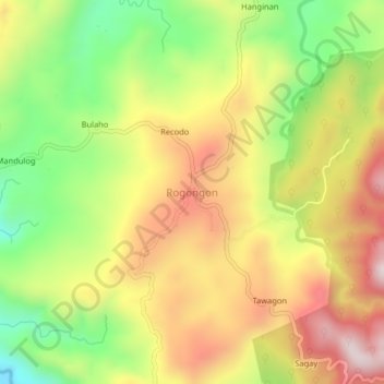
Name: Rogongon topographic map, elevation, terrain.

Location: Rogongon, Iligan, Northern Mindanao, Philippines (8.21886 124.39137 8.25886 124.43137)

Average elevation: 405 m

Minimum elevation: 95 m

Maximum elevation: 709 m

Other topographic maps

Click on a map to view its topography, its elevation and its terrain.

Kiwalan

Philippines > Iligan

Average elevation: 74 m

Mandulog River

Philippines > Iligan > San Roque

Average elevation: 79 m

Iponan River

Philippines > Iligan

Average elevation: 563 m

Bayug River

Philippines > Iligan > Lanipao

Average elevation: 154 m

Iligan City Wet Park

Philippines > Iligan

Average elevation: 17 m

Gear up for your next adventure:

🗺️Topographic Maps - Detailed maps to explore trails, mountains, and wilderness areas
🕶️Polarized Sunglasses - Protect your eyes with durable polarized lenses
🥾Hiking Gaiters - Protect legs and shoes from mud, snow, and debris
👖Convertible Hiking Pants - Zip-off legs to adapt to changing weather conditions
🥾Mountain Hiking Shoes - Shoes with superior grip for mountainous terrain

As an Amazon Associate, this site earns from qualifying purchases at no extra cost to you.