Geolocate

Sesar Lembang topographic map

Click on the map to display elevation.

About this map

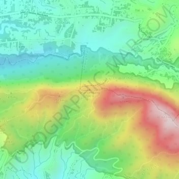
Name: Sesar Lembang topographic map, elevation, terrain.

Location: Sesar Lembang, Kabupaten Bandung, Java, 40197, Indonesia (-6.83550 107.69067 -6.83540 107.69077)

Average elevation: 1,344 m

Minimum elevation: 1,161 m

Maximum elevation: 1,637 m

Other topographic maps

Click on a map to view its topography, its elevation and its terrain.

Soreang

Indonesia > Kabupaten Bandung

Average elevation: 745 m

Gear up for your next adventure:

🔭Compact Binoculars - Lightweight optics for scouting trails and wildlife
💧Hydration Pack - Hands-free hydration system for long hikes
💡LED Camping Lantern - Illuminate your campsite with long-lasting lanterns
🥾Mountain Hiking Boots - High-traction boots for rocky terrain
🧥Insulated Jacket - Keep warm in cold outdoor conditions

As an Amazon Associate, this site earns from qualifying purchases at no extra cost to you.