Geolocate

Mason topographic map

Click on the map to display elevation.

About this map

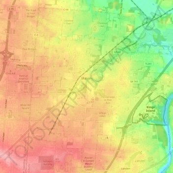
Name: Mason topographic map, elevation, terrain.

Location: Mason, Warren County, Ohio, 45040, United States (39.30954 -84.34933 39.40161 -84.25276)

Average elevation: 248 m

Minimum elevation: 178 m

Maximum elevation: 301 m

Gear up for your next adventure:

👟Sport Hiking Sandals - Breathable footwear for water crossings and camp rest
🧥Waterproof Hiking Jacket - Protect yourself from rain and wind while hiking
🎒Fully Waterproof Backpack - Total protection for photography gear and electronics
🥾Waterproof Hiking Boots - Essential footwear for rugged terrain and wet Canadian trails
🔭Compact Binoculars - Lightweight optics for scouting trails and wildlife

As an Amazon Associate, this site earns from qualifying purchases at no extra cost to you.