Geolocate

Lilydale topographic map

Click on the map to display elevation.

About this map

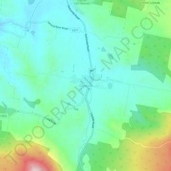
Name: Lilydale topographic map, elevation, terrain.

Location: Lilydale, Tasmania, 7268, Australia (-41.27112 147.19563 -41.23112 147.23563)

Average elevation: 225 m

Minimum elevation: 124 m

Maximum elevation: 528 m

Gear up for your next adventure:

🚑Survival Whistle - Signal for help across long distances in mountains
🧴Sunscreen SPF - Broad-spectrum sunscreen for outdoor activities
🍽️Titanium Camping Spork - Ultralight and indestructible eating utensil
🔦LED Flashlight - Powerful and long-lasting flashlight for camping and emergencies
🧰Survival Kit - Essential gear for emergencies in the wilderness

As an Amazon Associate, this site earns from qualifying purchases at no extra cost to you.