Geolocate

Monfero topographic map

Click on the map to display elevation.

About this map

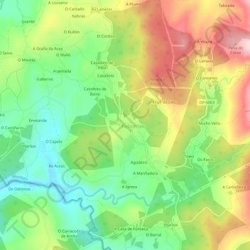
Name: Monfero topographic map, elevation, terrain.

Location: Monfero, Eume, La Coruña, Galicia, 15315, España (43.31433 -8.07530 43.35433 -8.03530)

Average elevation: 352 m

Minimum elevation: 234 m

Maximum elevation: 507 m

Gear up for your next adventure:

🥾Light Hiking Boots - Lightweight and comfortable boots for day hikes
🧢Outdoor Visor - Breathable visor for sunny hikes
👟Leg Gaiters - Keep debris, mud, and snow out of your boots
🥾Hiking Shorts - Breathable shorts suitable for summer hikes
🧥Insulated Jacket - Keep warm in cold outdoor conditions

As an Amazon Associate, this site earns from qualifying purchases at no extra cost to you.