
Thank you for supporting this site ❤️
Make a donation
Make a donation
Gear up for your next adventure:
As an Amazon Associate, this site earns from qualifying purchases at no extra cost to you.
Jatunloma topographic map
Click on the map to display elevation.
Thank you for supporting this site ❤️
Make a donation
Make a donation
Gear up for your next adventure:
As an Amazon Associate, this site earns from qualifying purchases at no extra cost to you.
About this map
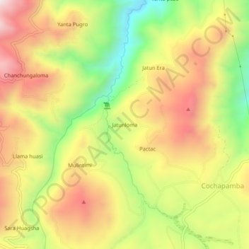
Name: Jatunloma topographic map, elevation, terrain.
Location: Jatunloma, Cochapamba, Saquisilí, Cotopaxi, Ecuador (-0.84783 -78.78855 -0.80783 -78.74855)
Average elevation: 3,674 m
Minimum elevation: 3,289 m
Maximum elevation: 4,022 m
Thank you for supporting this site ❤️
Make a donation
Make a donation
Gear up for your next adventure:
As an Amazon Associate, this site earns from qualifying purchases at no extra cost to you.