Geolocate

Tallón topographic map

Click on the map to display elevation.

About this map

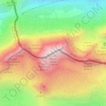
Name: Tallón topographic map, elevation, terrain.

Location: Tallón, Sobrarbe, Huesca, Aragón, España (42.69359 -0.05134 42.69369 -0.05124)

Average elevation: 2,583 m

Minimum elevation: 2,035 m

Maximum elevation: 3,136 m

Other topographic maps

Click on a map to view its topography, its elevation and its terrain.

Boltaña

España > Aragón > Sobrarbe

Average elevation: 859 m

La Fueva

España > Aragón > Sobrarbe

Average elevation: 923 m

Tella-Sin

España > Aragón > Sobrarbe

Average elevation: 1,448 m

Embalse de Mediano

España > Aragón > Sobrarbe

Average elevation: 649 m

Cañón de Añisclo

España > Aragón > Sobrarbe

Average elevation: 1,487 m

Gear up for your next adventure:

🧦Merino Wool Socks - Moisture-wicking comfort for long-distance hiking
🥤Collapsible Travel Cup - Saves space and weight in your mess kit
🛌Down Sleeping Bag - Superior warmth-to-weight ratio for cold nights
🚲Heavy Duty Bike Lock - Secure your bike at the trailhead or during stops
🧤Thermal Hiking Gloves - Grip-enhanced gloves for cold-weather altitude trekking

As an Amazon Associate, this site earns from qualifying purchases at no extra cost to you.