Geolocate

Argentona topographic map

Click on the map to display elevation.

About this map

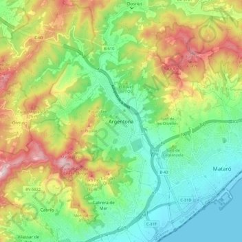
Name: Argentona topographic map, elevation, terrain.

Location: Argentona, Maresme, Barcelona, Cataluña, 08310, España (41.51543 2.36028 41.59543 2.44028)

Average elevation: 179 m

Minimum elevation: 0 m

Maximum elevation: 478 m

Gear up for your next adventure:

🛌Down Sleeping Bag - Superior warmth-to-weight ratio for cold nights
🥾Trail Hiking Socks - Comfortable socks to prevent blisters and fatigue
🧢Sun Protection Cap - Breathable cap to protect from sun exposure
💧Reusable Water Bottle - Durable water bottles for hydration on trails
🔭Outdoor Binoculars - Lightweight binoculars for birdwatching and hiking

As an Amazon Associate, this site earns from qualifying purchases at no extra cost to you.