Geolocate

Thornton topographic map

Click on the map to display elevation.

About this map

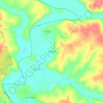
Name: Thornton topographic map, elevation, terrain.

Location: Thornton, Lawrence County, Indiana, 47451, United States (38.89672 -86.52138 38.93672 -86.48138)

Average elevation: 174 m

Minimum elevation: 142 m

Maximum elevation: 223 m

Other topographic maps

Click on a map to view its topography, its elevation and its terrain.

Bedford

United States > Indiana > Lawrence County

Average elevation: 191 m

Mitchell

United States > Indiana > Lawrence County

Average elevation: 209 m

Bedford

United States > Indiana > Lawrence County

Average elevation: 191 m

Gear up for your next adventure:

🔭Compact Monocular - One-handed bird watching and trail spotting
🥾Waterproof Hiking Shoes - Durable shoes for wet and rugged trails
🔨Vehicle Emergency Tool - Safety tool for remote road trips to trailheads
🥾Light Hiking Boots - Lightweight and comfortable boots for day hikes
🦯Trekking Poles - Reduced impact on joints for steep topographic climbs

As an Amazon Associate, this site earns from qualifying purchases at no extra cost to you.