
Thank you for supporting this site ❤️
Make a donation
Make a donation
Gear up for your next adventure:
As an Amazon Associate, this site earns from qualifying purchases at no extra cost to you.
Tahalket topographic map
Click on the map to display elevation.
Thank you for supporting this site ❤️
Make a donation
Make a donation
Gear up for your next adventure:
As an Amazon Associate, this site earns from qualifying purchases at no extra cost to you.
About this map
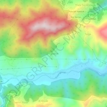
Name: Tahalket topographic map, elevation, terrain.
Location: Tahalket, Tichy, Daïra Tichy, Béjaïa, 06023, Algérie (36.61824 5.12995 36.65824 5.16995)
Average elevation: 263 m
Minimum elevation: 25 m
Maximum elevation: 637 m
Thank you for supporting this site ❤️
Make a donation
Make a donation
Gear up for your next adventure:
As an Amazon Associate, this site earns from qualifying purchases at no extra cost to you.