
Make a donation
Gear up for your next adventure:
As an Amazon Associate, this site earns from qualifying purchases at no extra cost to you.
Stewardson Township topographic map
Click on the map to display elevation.
Make a donation
Gear up for your next adventure:
As an Amazon Associate, this site earns from qualifying purchases at no extra cost to you.
About this map
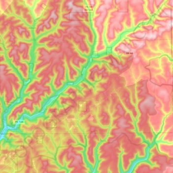
Name: Stewardson Township topographic map, elevation, terrain.
Average elevation: 557 m
Minimum elevation: 311 m
Maximum elevation: 722 m
Make a donation
Gear up for your next adventure:
As an Amazon Associate, this site earns from qualifying purchases at no extra cost to you.
Other topographic maps
Click on a map to view its topography, its elevation and its terrain.
Cross Fork
United States > Pennsylvania > Potter County > Stewardson Township
Average elevation: 467 m
Make a donation
Gear up for your next adventure:
As an Amazon Associate, this site earns from qualifying purchases at no extra cost to you.
Cross Fork
United States > Pennsylvania > Potter County > Stewardson Township
Average elevation: 467 m
Patterson State Park
United States > Pennsylvania > Potter County > Summit Township
Average elevation: 708 m
Kinney
United States > Pennsylvania > Potter County > Genesee Township > Kinney
Average elevation: 660 m
Make a donation
Gear up for your next adventure:
As an Amazon Associate, this site earns from qualifying purchases at no extra cost to you.