
Oering topographic map
Click on the map to display elevation.
About this map
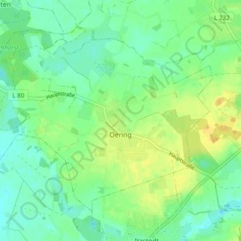
Name: Oering topographic map, elevation, terrain.
Location: Oering, Itzstedt, Kreis Segeberg, Schleswig-Holstein, Germany (53.81061 10.10741 53.84146 10.17227)
Average elevation: 33 m
Minimum elevation: 23 m
Maximum elevation: 47 m
Other topographic maps
Click on a map to view its topography, its elevation and its terrain.
Strand Seekamp
Germany > Schleswig-Holstein > Kreis Segeberg > Berlin > Seekamp
Average elevation: 38 m