Geolocate

la Llagosta topographic map

Click on the map to display elevation.

About this map

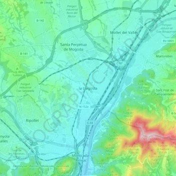
Name: la Llagosta topographic map, elevation, terrain.

Location: la Llagosta, Vallés Oriental, Barcelona, Cataluña, 08120, España (41.47399 2.15121 41.55399 2.23121)

Average elevation: 107 m

Minimum elevation: 24 m

Maximum elevation: 455 m

Gear up for your next adventure:

🕯️Camping Lantern - Illuminates your entire campsite with high-efficiency LEDs
🔋Emergency Crank Radio - Weather alerts and power without needing batteries
🧢Sun Hat - Wide-brim hat for sun protection
🩹Moleskin Blister Pads - Direct protection for painful foot pressure points
🦶Hiking Shoe Insoles - Added support for high arches and long days on feet

As an Amazon Associate, this site earns from qualifying purchases at no extra cost to you.