
Thank you for supporting this site ❤️
Make a donation
Make a donation
Gear up for your next adventure:
As an Amazon Associate, this site earns from qualifying purchases at no extra cost to you.
Coux-et-Bigaroque topographic map
Click on the map to display elevation.
Thank you for supporting this site ❤️
Make a donation
Make a donation
Gear up for your next adventure:
As an Amazon Associate, this site earns from qualifying purchases at no extra cost to you.
About this map
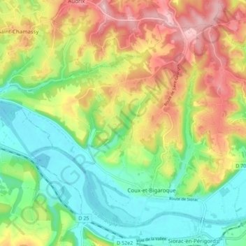
Name: Coux-et-Bigaroque topographic map, elevation, terrain.
Average elevation: 130 m
Minimum elevation: 48 m
Maximum elevation: 246 m
Thank you for supporting this site ❤️
Make a donation
Make a donation
Gear up for your next adventure:
As an Amazon Associate, this site earns from qualifying purchases at no extra cost to you.
Other topographic maps
Click on a map to view its topography, its elevation and its terrain.
Les Valades
Frankrijk > Nieuw-Aquitanië > Dordogne > Coux et Bigaroque-Mouzens
Average elevation: 155 m
La Geneste
Frankrijk > Nieuw-Aquitanië > Dordogne > Coux et Bigaroque-Mouzens > La Geneste
Average elevation: 110 m