Geolocate

Kaytitinga I topographic map

Click on the map to display elevation.

About this map

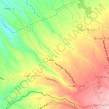
Name: Kaytitinga I topographic map, elevation, terrain.

Location: Kaytitinga I, Alfonso, Cavite, Calabarzon, 4123, Philippines (14.08757 120.80796 14.12757 120.84796)

Average elevation: 431 m

Minimum elevation: 313 m

Maximum elevation: 526 m

Other topographic maps

Click on a map to view its topography, its elevation and its terrain.

Amuyong

Philippines > Cavite > Alfonso

Average elevation: 543 m

Amuyong

Philippines > Cavite > Alfonso

Average elevation: 543 m

Gear up for your next adventure:

🥾Waterproof Hiking Boots - Boots keeping your feet dry in wet conditions
👟Leg Gaiters - Keep debris, mud, and snow out of your boots
🧳Compression Sacks - Maximize space in your backpack by shrinking gear
🩹Compact First Aid Kit - Pre-packed essentials for common trail injuries
🚲Heavy Duty Bike Lock - Secure your bike at the trailhead or during stops

As an Amazon Associate, this site earns from qualifying purchases at no extra cost to you.