Geolocate

Arbat District topographic map

Click on the map to display elevation.

About this map

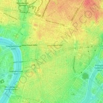
Name: Arbat District topographic map, elevation, terrain.

Location: Arbat District, Moscow, Central Federal District, Russia (55.74375 37.57206 55.75811 37.61224)

Average elevation: 143 m

Minimum elevation: 113 m

Maximum elevation: 170 m

Other topographic maps

Click on a map to view its topography, its elevation and its terrain.

Парк имени 1 мая

Russia > Moscow > Moscow

Average elevation: 142 m

Moscow Canal Lock №11

Russia > Moscow > Moscow

Average elevation: 123 m

Gear up for your next adventure:

🧳Compression Sacks - Maximize space in your backpack by shrinking gear
👖Convertible Hiking Pants - Zip-off legs to adapt to changing weather conditions
Camping Essentials - All-in-one gear for a comfortable camping trip
🧦Hiking Socks - Moisture-wicking and comfortable socks for long hikes
🥾Approach Boots - Comfortable boots for hiking and climbing approaches

As an Amazon Associate, this site earns from qualifying purchases at no extra cost to you.