Geolocate

Kot topographic map

Click on the map to display elevation.

About this map

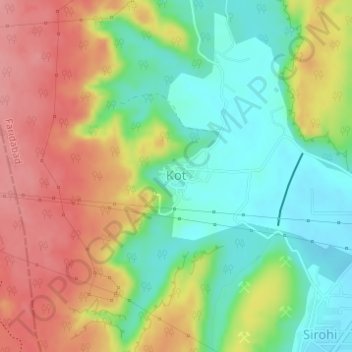
Name: Kot topographic map, elevation, terrain.

Location: Kot, Faridabad, Haryana, India (28.33180 77.16606 28.33465 77.16970)

Average elevation: 251 m

Minimum elevation: 204 m

Maximum elevation: 304 m

Gear up for your next adventure:

🚑Survival Whistle - Signal for help across long distances in mountains
🥾Mountain Hiking Boots - High-traction boots for rocky terrain
🥾Hiking Leggings - Comfortable leggings for outdoor activities
🧢Hiking Sun Hat - Wide-brimmed protection for exposed mountain ridges
🔦LED Headlamp - Hands-free lighting for early morning starts or late finishes

As an Amazon Associate, this site earns from qualifying purchases at no extra cost to you.