Geolocate

Wailua topographic map

Click on the map to display elevation.

About this map

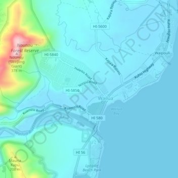
Name: Wailua topographic map, elevation, terrain.

Location: Wailua, Kauaʻi County, Hawaii, United States (22.04438 -159.35794 22.06314 -159.31665)

Average elevation: 39 m

Minimum elevation: -2 m

Maximum elevation: 329 m

Other topographic maps

Click on a map to view its topography, its elevation and its terrain.

Gear up for your next adventure:

🦯Trekking Poles - Reduced impact on joints for steep topographic climbs
🧢Sun Hat - Wide-brim hat for sun protection
🧦Hiking Socks - Moisture-wicking and comfortable socks for long hikes
🧊Portable Cooler - Keep food and drinks cold during outdoor adventures
🧭GPS Handheld Device - Reliable GPS navigation for outdoor adventures

As an Amazon Associate, this site earns from qualifying purchases at no extra cost to you.