
Thank you for supporting this site ❤️
Make a donation
Make a donation
Gear up for your next adventure:
As an Amazon Associate, this site earns from qualifying purchases at no extra cost to you.
Durham topographic map
Click on the map to display elevation.
Thank you for supporting this site ❤️
Make a donation
Make a donation
Gear up for your next adventure:
As an Amazon Associate, this site earns from qualifying purchases at no extra cost to you.
About this map
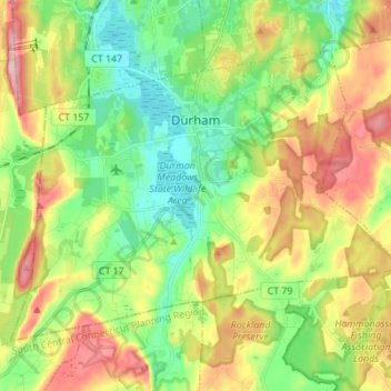
Name: Durham topographic map, elevation, terrain.
Location: Durham, Middlesex County, Connecticut, 06422, United States (41.42348 -72.74643 41.50021 -72.60896)
Average elevation: 121 m
Minimum elevation: 38 m
Maximum elevation: 249 m
Thank you for supporting this site ❤️
Make a donation
Make a donation
Gear up for your next adventure:
As an Amazon Associate, this site earns from qualifying purchases at no extra cost to you.
Other topographic maps
Click on a map to view its topography, its elevation and its terrain.
Newfield Heights
United States > Connecticut > Middlesex County > Middletown > Newfield Heights
Average elevation: 42 m