
Thank you for supporting this site ❤️
Make a donation
Make a donation
Gear up for your next adventure:
As an Amazon Associate, this site earns from qualifying purchases at no extra cost to you.
Gökpınar topographic map
Click on the map to display elevation.
Thank you for supporting this site ❤️
Make a donation
Make a donation
Gear up for your next adventure:
As an Amazon Associate, this site earns from qualifying purchases at no extra cost to you.
About this map
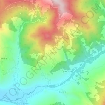
Name: Gökpınar topographic map, elevation, terrain.
Location: Gökpınar, Safranbolu, Karabük, Région de la mer Noire, Turquie (41.44719 32.74752 41.48719 32.78752)
Average elevation: 585 m
Minimum elevation: 342 m
Maximum elevation: 991 m
Thank you for supporting this site ❤️
Make a donation
Make a donation
Gear up for your next adventure:
As an Amazon Associate, this site earns from qualifying purchases at no extra cost to you.