Geolocate

Ledbetter topographic map

Click on the map to display elevation.

About this map

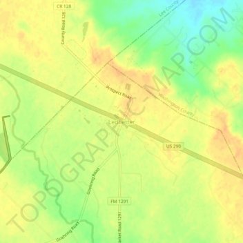
Name: Ledbetter topographic map, elevation, terrain.

Location: Ledbetter, Fayette County, Texas, 78946, United States (30.13091 -96.81172 30.17091 -96.77172)

Average elevation: 128 m

Minimum elevation: 108 m

Maximum elevation: 139 m

Other topographic maps

Click on a map to view its topography, its elevation and its terrain.

Cedar Creek Dam

United States > Texas > Fayette County > Tamberg

Average elevation: 113 m

Round Top

United States > Texas > Fayette County

Average elevation: 119 m

La Grange

United States > Texas > Fayette County

The center of La Grange has an elevation of 266 feet (81 m) above sea level.

Average elevation: 91 m

Fayetteville

United States > Texas > Fayette County

Average elevation: 124 m

Schulenburg

United States > Texas > Fayette County

Average elevation: 103 m

La Grange

United States > Texas > Fayette County

The center of La Grange has an elevation of 266 feet (81 m) above sea level.

Average elevation: 91 m

Gear up for your next adventure:

🧥Softshell Hiking Jacket - The perfect balance of wind protection and breathability
🔥Camping Stove - Portable stoves to cook outdoors with ease
🥾Trekking Boots - Durable boots for long-distance trekking
🪑Insulated Seat Pad - Protect your seat from cold rocks and wet logs
🥾Waterproof Hiking Shoes - Durable shoes for wet and rugged trails

As an Amazon Associate, this site earns from qualifying purchases at no extra cost to you.