
Thank you for supporting this site ❤️
Make a donation
Make a donation
Gear up for your next adventure:
As an Amazon Associate, this site earns from qualifying purchases at no extra cost to you.
Hikurangi topographic map
Click on the map to display elevation.
Thank you for supporting this site ❤️
Make a donation
Make a donation
Gear up for your next adventure:
As an Amazon Associate, this site earns from qualifying purchases at no extra cost to you.
About this map
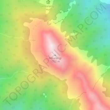
Name: Hikurangi topographic map, elevation, terrain.
Location: Hikurangi, Gisborne District, Gisborne, New Zealand (-37.91898 178.06069 -37.91888 178.06079)
Average elevation: 1,260 m
Minimum elevation: 794 m
Maximum elevation: 1,743 m
Thank you for supporting this site ❤️
Make a donation
Make a donation
Gear up for your next adventure:
As an Amazon Associate, this site earns from qualifying purchases at no extra cost to you.