
Make a donation
Gear up for your next adventure:
As an Amazon Associate, this site earns from qualifying purchases at no extra cost to you.
Retournac topographic map
Click on the map to display elevation.
Make a donation
Gear up for your next adventure:
As an Amazon Associate, this site earns from qualifying purchases at no extra cost to you.
About this map
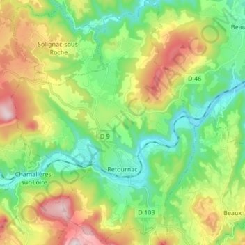
Name: Retournac topographic map, elevation, terrain.
Average elevation: 690 m
Minimum elevation: 478 m
Maximum elevation: 1,079 m
Make a donation
Gear up for your next adventure:
As an Amazon Associate, this site earns from qualifying purchases at no extra cost to you.
Other topographic maps
Click on a map to view its topography, its elevation and its terrain.
Les Ardennes
Frankrijk > Auvergne-Rhône-Alpes > Haute-Loire > Saint-Julien-Chapteuil
Average elevation: 1,090 m
Make a donation
Gear up for your next adventure:
As an Amazon Associate, this site earns from qualifying purchases at no extra cost to you.
Le Rocher du Poulain
Frankrijk > Auvergne-Rhône-Alpes > Haute-Loire > Saint-Pal-de-Mons
Average elevation: 781 m
Le Puy-en-Velay
Frankrijk > Auvergne-Rhône-Alpes > Haute-Loire > Le Puy-en-Velay > Le Puy-en-Velay
Average elevation: 727 m
Make a donation
Gear up for your next adventure:
As an Amazon Associate, this site earns from qualifying purchases at no extra cost to you.