Geolocate

Livata topographic map

Click on the map to display elevation.

About this map

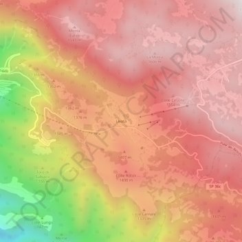
Name: Livata topographic map, elevation, terrain.

Location: Livata, Subiaco, Roma Capitale, Lazio, 00028, Italy (41.91978 13.12658 41.95978 13.16658)

Average elevation: 1,333 m

Minimum elevation: 633 m

Maximum elevation: 1,666 m

Gear up for your next adventure:

💡Portable Camping Lamp - Rechargeable lamp for campsite lighting
🚑Survival Whistle - Signal for help across long distances in mountains
🔦LED Headlamp - Hands-free lighting for early morning starts or late finishes
🪜Heavy Duty Carabiners - Multi-use clips for securing gear to your backpack
🥾Waterproof Trail Shoes - Shoes designed to handle wet terrain

As an Amazon Associate, this site earns from qualifying purchases at no extra cost to you.