
Strand topographic map
Click on the map to display elevation.
About this map
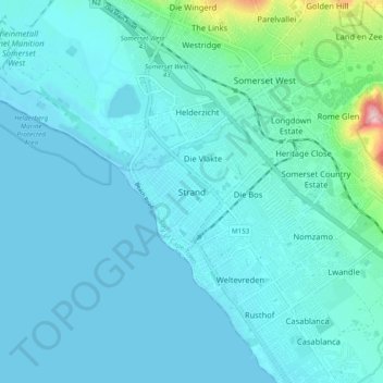
Name: Strand topographic map, elevation, terrain.
Location: Strand, City of Cape Town, Western Cape, 7139, South Africa (-34.14556 18.79056 -34.06556 18.87056)
Average elevation: 22 m
Minimum elevation: 0 m
Maximum elevation: 204 m
Other topographic maps
Click on a map to view its topography, its elevation and its terrain.
Durbanville
South Africa > Western Cape > City of Cape Town
Durbanville is situated in the northern suburbs of Cape Town, approximately 28 kilometres (17.4 mi) north-east of the city, bordered by Bellville to the south, Brackenfell to the south-east and Kraaifontein to the east. It lies at an altitude of between 100 m (328 ft) to 240 m (787 ft), in the vast rolling…
Average elevation: 157 m
Table Mountain
South Africa > Western Cape > City of Cape Town > Cape Town
Table Mountain is at the northern end of a sandstone mountain range that forms the spine of the Cape Peninsula that terminates approximately 50 kilometres (30 mi) to the south at the Cape of Good Hope and Cape Point. Immediately to the south of Table Mountain is a rugged "plateau" at a somewhat lower elevation…
Average elevation: 583 m
Durbanville
South Africa > Western Cape > City of Cape Town
Durbanville is situated in the northern suburbs of Cape Town, approximately 28 kilometres (17.4 mi) north-east of the city, bordered by Bellville to the south, Brackenfell to the south-east and Kraaifontein to the east. It lies at an altitude of between 100 m (328 ft) to 240 m (787 ft), in the vast rolling…
Average elevation: 157 m
Helderberg Nature Reserve
South Africa > Western Cape > City of Cape Town > Somerset West
Average elevation: 343 m
Station Road Childrens Park
South Africa > Western Cape > City of Cape Town > Cape Town
Average elevation: 40 m
Robben Island
South Africa > Western Cape > City of Cape Town > Robben Island Village
Average elevation: 5 m
False Bay
South Africa > Western Cape > City of Cape Town
Local variations in wind direction and strength are caused by interaction with the mountains on both sides of the bay. South-easterly winds are accelerated northwest of Cape Hangklip, and a distinct wind shadow can develop in the lee of the Kogelberg mountain. Northwesterly winds accelerate over Table Mountain…
Average elevation: 28 m
Table Mountain National Park
South Africa > Western Cape > City of Cape Town > Pine Haven
Average elevation: 37 m
Table Mountain
South Africa > Western Cape > City of Cape Town > Cape Town
Table Mountain is at the northern end of a sandstone mountain range that forms the spine of the Cape Peninsula that terminates approximately 50 kilometres (30 mi) to the south at the Cape of Good Hope and Cape Point. Immediately to the south of Table Mountain is a rugged "plateau" at a somewhat lower elevation…
Average elevation: 583 m
False Bay
South Africa > Western Cape > City of Cape Town
Local variations in wind direction and strength are caused by interaction with the mountains on both sides of the bay. South-easterly winds are accelerated northwest of Cape Hangklip, and a distinct wind shadow can develop in the lee of the Kogelberg mountain. Northwesterly winds accelerate over Table Mountain…
Average elevation: 28 m
Table Mountain National Park
South Africa > Western Cape > City of Cape Town > Pine Haven
Average elevation: 37 m
Table Mountain
South Africa > Western Cape > City of Cape Town > Cape Town
Table Mountain is at the northern end of a sandstone mountain range that forms the spine of the Cape Peninsula that terminates approximately 50 kilometres (30 mi) to the south at the Cape of Good Hope and Cape Point. Immediately to the south of Table Mountain is a rugged "plateau" at a somewhat lower elevation…
Average elevation: 578 m
Durbanville
South Africa > Western Cape > City of Cape Town
Durbanville is situated in the northern suburbs of Cape Town, approximately 28 kilometres (17.4 mi) north-east of the city, bordered by Bellville to the south, Brackenfell to the south-east and Kraaifontein to the east. It lies at an altitude of between 100 m (328 ft) to 240 m (787 ft), in the vast rolling…
Average elevation: 157 m
Cathkin Park
South Africa > Western Cape > City of Cape Town > Mitchells Plain
Average elevation: 15 m
Table Mountain National Park
South Africa > Western Cape > City of Cape Town > Pine Haven
Average elevation: 37 m
Castle of Good Hope
South Africa > Western Cape > City of Cape Town > Cape Town
Average elevation: 38 m