Geolocate

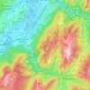
Perriche topographic map

Click on the map to display elevation.

About this map

Name: Perriche topographic map, elevation, terrain.

Location: Perriche, Saint-Pierre-de-Chartreuse, Grenoble, Isère, Auvergne-Rhône-Alpes, France métropolitaine, 38380, France (45.33505 5.80649 45.37505 5.84649)

Average elevation: 1,274 m

Minimum elevation: 782 m

Maximum elevation: 2,024 m

Other topographic maps

Click on a map to view its topography, its elevation and its terrain.
Gear up for your next adventure:

🥾Hiking Shorts - Breathable shorts suitable for summer hikes
🥾Hiking Boots - Sturdy boots providing ankle support and traction on rugged trails
🥾Trekking Boots - Durable boots for long-distance trekking
💡Compact LED Flashlight - Powerful and portable flashlight for outdoor use
🥾Hiking Leggings - Comfortable leggings for outdoor activities

As an Amazon Associate, this site earns from qualifying purchases at no extra cost to you.