
Make a donation
Gear up for your next adventure:
As an Amazon Associate, this site earns from qualifying purchases at no extra cost to you.
Blajoux topographic map
Click on the map to display elevation.
Make a donation
Gear up for your next adventure:
As an Amazon Associate, this site earns from qualifying purchases at no extra cost to you.
About this map
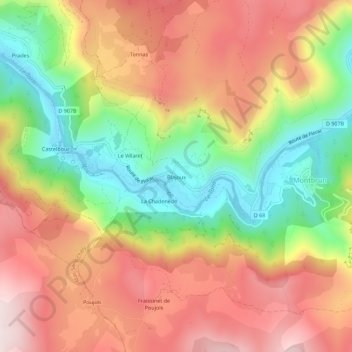
Name: Blajoux topographic map, elevation, terrain.
Average elevation: 779 m
Minimum elevation: 475 m
Maximum elevation: 1,057 m
Make a donation
Gear up for your next adventure:
As an Amazon Associate, this site earns from qualifying purchases at no extra cost to you.
Other topographic maps
Click on a map to view its topography, its elevation and its terrain.
Sainte-Enimie
France > Occitanie > Lozère > Gorges du Tarn Causses
Entre le causse Sauveterre au nord et le causse Méjean au sud, deux plateaux d'altitude moyenne supérieure à 1 000 m, le Tarn s'écoule dans de grandioses gorges. Ses rives sont couvertes par la forêt domaniale des gorges du Tarn.
Average elevation: 899 m