Geolocate

CINTA MATA topographic map

Click on the map to display elevation.

About this map

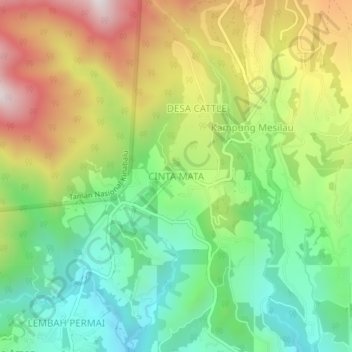
Name: CINTA MATA topographic map, elevation, terrain.

Location: CINTA MATA, Sabah, Malaysia (5.98864 116.56902 6.02864 116.60902)

Average elevation: 1,480 m

Minimum elevation: 1,127 m

Maximum elevation: 1,993 m

Other topographic maps

Click on a map to view its topography, its elevation and its terrain.

Mabul Island

Malaysia > Sabah

Average elevation: 0 m

Gear up for your next adventure:

🥾Waterproof Hiking Boots - Boots keeping your feet dry in wet conditions
🌡️Emergency Mylar Blankets - Compact thermal protection for unexpected nights outdoors
🥾Trail Hiking Boots - Supportive boots for rough trails
🧥Insulated Jacket - Keep warm in cold outdoor conditions
🔦LED Headlamp - Hands-free lighting for early morning starts or late finishes

As an Amazon Associate, this site earns from qualifying purchases at no extra cost to you.