Geolocate

The Redoubt topographic map

Click on the map to display elevation.

About this map

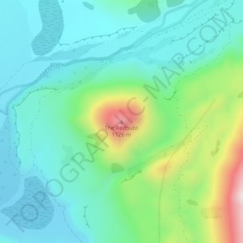
Name: The Redoubt topographic map, elevation, terrain.

Location: The Redoubt, Selwyn District, New Zealand (-43.18828 171.56277 -43.18818 171.56287)

Average elevation: 754 m

Minimum elevation: 606 m

Maximum elevation: 1,202 m

Other topographic maps

Click on a map to view its topography, its elevation and its terrain.

Lake Pearson

New Zealand > Selwyn District

Average elevation: 822 m

Torlesse Range

New Zealand > Selwyn District

Average elevation: 1,059 m

Big Ben Range

New Zealand > Selwyn District

Average elevation: 1,190 m

Craigieburn Range

New Zealand > Selwyn District

Average elevation: 1,168 m

Polar Range

New Zealand > Selwyn District

Average elevation: 1,454 m

Lake Minchin

New Zealand > Selwyn District

Average elevation: 1,092 m

Cascade Range

New Zealand > Selwyn District

Average elevation: 1,266 m

Cascade Range

New Zealand > Selwyn District

Average elevation: 1,266 m

Gear up for your next adventure:

🧭GPS Outdoor Watch - Smart watch for navigation and fitness tracking in nature
🛏️Sleeping Bag - Warm and compact sleeping bags for outdoor camping
🦶Anti-Blister Balm - Prevents friction and hotspots during long ascents
🧴First Aid Kit - Essential first aid supplies for outdoor emergencies
🌡️Emergency Mylar Blankets - Compact thermal protection for unexpected nights outdoors

As an Amazon Associate, this site earns from qualifying purchases at no extra cost to you.