Geolocate

Trasi topographic map

Click on the map to display elevation.

About this map

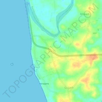
Name: Trasi topographic map, elevation, terrain.

Location: Trasi, Kundapura, Udupi, Karnataka, 576247, India (13.66998 74.63206 13.70998 74.67206)

Average elevation: 11 m

Minimum elevation: 0 m

Maximum elevation: 37 m

Other topographic maps

Click on a map to view its topography, its elevation and its terrain.

Koni

India > Karnataka > Kundapura

Average elevation: 12 m

Ulluru

India > Karnataka > Kundapura

Average elevation: 52 m

Kalawara

India > Karnataka > Kundapura > Kalavara

Average elevation: 19 m

Koni

India > Karnataka > Kundapura > Koni

Average elevation: 12 m

Gear up for your next adventure:

🥾Approach Shoes - Shoes designed for climbing approaches and rugged trails
🧳Compression Sacks - Maximize space in your backpack by shrinking gear
🔦LED Headtorch - Bright and durable light for night activities
🥾Hiking Boots - Sturdy boots providing ankle support and traction on rugged trails
🧤Insulated Winter Gloves - Heavy-duty protection for sub-zero Canadian adventures

As an Amazon Associate, this site earns from qualifying purchases at no extra cost to you.