Geolocate

Denmark topographic map

Click on the map to display elevation.

About this map

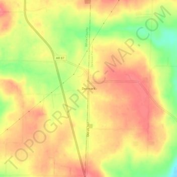
Name: Denmark topographic map, elevation, terrain.

Location: Denmark, Jackson County, Arkansas, United States (35.46425 -91.60319 35.50425 -91.56319)

Average elevation: 173 m

Minimum elevation: 128 m

Maximum elevation: 197 m

Other topographic maps

Click on a map to view its topography, its elevation and its terrain.

Tuckerman

United States > Arkansas > Jackson County

Average elevation: 74 m

Diaz

United States > Arkansas > Jackson County

Average elevation: 71 m

Amagon

United States > Arkansas > Jackson County

Average elevation: 69 m

Grubbs

United States > Arkansas > Jackson County

Average elevation: 71 m

Swifton

United States > Arkansas > Jackson County

Average elevation: 75 m

Gear up for your next adventure:

🕶️Polarized Sunglasses - Protect your eyes with durable polarized lenses
🎒Hiking Backpack - Lightweight and ergonomic backpacks for day hikes or multi-day treks
🕶️Polarized Sunglasses - Reduces glare from snow and water at high elevations
🔭Outdoor Binoculars - Lightweight binoculars for birdwatching and hiking
Lightweight Backpacking Tent - Compact tent for efficient hiking trips

As an Amazon Associate, this site earns from qualifying purchases at no extra cost to you.