
Mount Cleveland topographic map
Click on the map to display elevation.
About this map
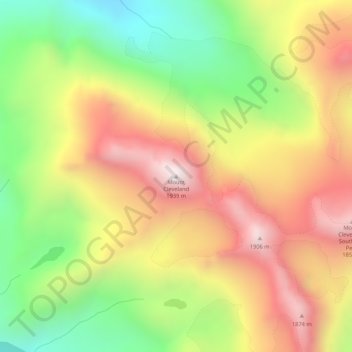
Name: Mount Cleveland topographic map, elevation, terrain.
Location: Mount Cleveland, Skagway, Alaska, United States (59.61019 -135.25187 59.61029 -135.25177)
Average elevation: 1,440 m
Minimum elevation: 958 m
Maximum elevation: 1,923 m
Other topographic maps
Click on a map to view its topography, its elevation and its terrain.
Skagway
United States > Alaska > Skagway > Liarsville Gold Rush Trail Camp & Salmon Bake
Average elevation: 551 m
Skagway
United States > Alaska > Skagway > Liarsville Gold Rush Trail Camp & Salmon Bake
Average elevation: 551 m
Skagway
United States > Alaska > Skagway > Liarsville Gold Rush Trail Camp & Salmon Bake
Average elevation: 551 m