
Baye topographic map
Interactive map
Click on the map to display elevation.
About this map
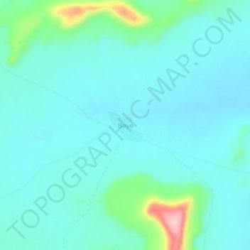
Name: Baye topographic map, elevation, terrain.
Location: Baye, Cercle de Kita, Kayes, Mali (13.06551 -9.99995 13.10551 -9.95995)
Average elevation: 326 m
Minimum elevation: 292 m
Maximum elevation: 496 m
Other topographic maps
Click on a map to view its topography, its elevation and its terrain.
Niagané
Mali > Kayes > Cercle de Kita > Niagané
Niagané, Cercle de Kita, Kayes, Mali
Average elevation: 273 m
Balandougou
Mali > Kayes > Cercle de Kita
Balandougou, Cercle de Kita, Kayes, Mali
Average elevation: 322 m