Geolocate

Portomarín topographic map

Click on the map to display elevation.

About this map

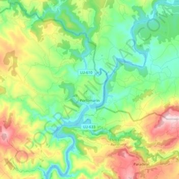
Name: Portomarín topographic map, elevation, terrain.

Location: Portomarín, Lugo, Galicia, Spain (42.75574 -7.76564 42.87528 -7.59868)

Average elevation: 474 m

Minimum elevation: 324 m

Maximum elevation: 777 m

Other topographic maps

Click on a map to view its topography, its elevation and its terrain.

Quintián

Spain > Galicia > Lugo

Average elevation: 490 m

Outeiro Pequeno

Spain > Galicia > Lugo > Portomarín

Average elevation: 530 m

Gear up for your next adventure:

🧥Waterproof Hiking Jacket - Protect yourself from rain and wind while hiking
🧤Insulated Winter Gloves - Heavy-duty protection for sub-zero Canadian adventures
🛶Kayak Accessories - Essential gear for safe and fun kayaking adventures
🧊Insulated Water Bottle - Keeps drinks cold in summer and prevents freezing in winter
🌡️Emergency Mylar Blankets - Compact thermal protection for unexpected nights outdoors

As an Amazon Associate, this site earns from qualifying purchases at no extra cost to you.