
Make a donation
Gear up for your next adventure:
As an Amazon Associate, this site earns from qualifying purchases at no extra cost to you.
Peracalç topographic map
Click on the map to display elevation.
Make a donation
Gear up for your next adventure:
As an Amazon Associate, this site earns from qualifying purchases at no extra cost to you.
Peracalç
Se encuentra situado en el sector meridional del municipio, al S del Pla de Corts, en la sierra que lleva su mismo nombre a 1200 m de altitud. Hasta allí se llega a través de una pista que nace de la que parte de Montcortés y va hacia Cabestany y Mentui.
Make a donation
Gear up for your next adventure:
As an Amazon Associate, this site earns from qualifying purchases at no extra cost to you.
About this map
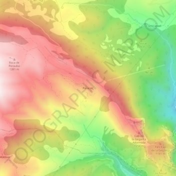
Name: Peracalç topographic map, elevation, terrain.
Average elevation: 1,046 m
Minimum elevation: 595 m
Maximum elevation: 1,417 m
Make a donation
Gear up for your next adventure:
As an Amazon Associate, this site earns from qualifying purchases at no extra cost to you.