Geolocate

Montgomery County topographic map

Click on the map to display elevation.

About this map

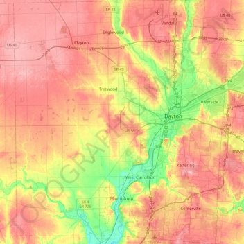
Name: Montgomery County topographic map, elevation, terrain.

Location: Montgomery County, Ohio, United States of America (39.57788 -84.48542 39.92265 -84.05099)

Average elevation: 277 m

Minimum elevation: 201 m

Maximum elevation: 334 m

Gear up for your next adventure:

🛌Insulated Sleeping Pad - Critical thermal barrier between you and the cold ground
🚑Survival Whistle - Signal for help across long distances in mountains
🎒Fully Waterproof Backpack - Total protection for photography gear and electronics
🧥Insulated Jacket - Keep warm in cold outdoor conditions
🏃Hydration Running Vest - Carry water and maps close to your body for speed

As an Amazon Associate, this site earns from qualifying purchases at no extra cost to you.