
Make a donation
Gear up for your next adventure:
As an Amazon Associate, this site earns from qualifying purchases at no extra cost to you.
Cervara topographic map
Click on the map to display elevation.
Make a donation
Gear up for your next adventure:
As an Amazon Associate, this site earns from qualifying purchases at no extra cost to you.
Cervara
Centro abitato della valle del Verde, si trova ad un'altitudine di 725 metri s.l.m.. Il territorio della frazione può essere suddiviso in tre località principali: Cervara alta, Cervara di mezzo e Cervara bassa.
Make a donation
Gear up for your next adventure:
As an Amazon Associate, this site earns from qualifying purchases at no extra cost to you.
About this map
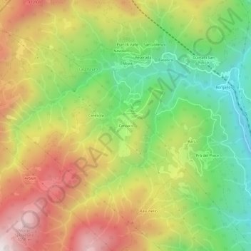
Name: Cervara topographic map, elevation, terrain.
Location: Cervara, Pontremoli, Massa-Carrara, Toscana, Italia (44.39892 9.79858 44.43892 9.83858)
Average elevation: 802 m
Minimum elevation: 379 m
Maximum elevation: 1,285 m
Make a donation
Gear up for your next adventure:
As an Amazon Associate, this site earns from qualifying purchases at no extra cost to you.