Geolocate

Alaminos topographic map

Click on the map to display elevation.

About this map

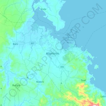
Name: Alaminos topographic map, elevation, terrain.

Location: Alaminos, Pangasinan, Ilocos Region, 2404, Philippines (15.99657 119.82045 16.31657 120.14045)

Average elevation: 44 m

Minimum elevation: -2 m

Maximum elevation: 643 m

Other topographic maps

Click on a map to view its topography, its elevation and its terrain.

Alos

Philippines > Pangasinan > Alaminos

Average elevation: 29 m

Santa Maria

Philippines > Pangasinan > Alaminos

Average elevation: 22 m

Victoria

Philippines > Pangasinan > Alaminos

Average elevation: 13 m

Bolaney

Philippines > Pangasinan > Alaminos

Average elevation: 18 m

Balayang

Philippines > Pangasinan > Alaminos

Average elevation: 30 m

San Vicente

Philippines > Pangasinan > Alaminos

Average elevation: 16 m

Tanaytay

Philippines > Pangasinan > Alaminos

Average elevation: 12 m

San Roque

Philippines > Pangasinan > Alaminos

Average elevation: 20 m

Bued

Philippines > Pangasinan > Alaminos

Average elevation: 12 m

Tangcarang

Philippines > Pangasinan > Alaminos

Average elevation: 23 m

Tangcarang

Philippines > Pangasinan > Alaminos

Average elevation: 23 m

Balangobong

Philippines > Pangasinan > Alaminos > Balangobong

Average elevation: 15 m

Gear up for your next adventure:

Camping Coffee Maker - Brew fresh coffee anywhere on the topographic map
🦟Insect Repellent - Keep mosquitoes and black flies away in wooded areas
🥾Mountain Hiking Boots - High-traction boots for rocky terrain
🧥Ultralight Puffy Jacket - Maximum warmth that packs down to the size of an orange
Lightweight Camping Tent - Portable shelter optimized for Canadian backcountry camping

As an Amazon Associate, this site earns from qualifying purchases at no extra cost to you.