Geolocate

Los Mochis topographic map

Click on the map to display elevation.

About this map

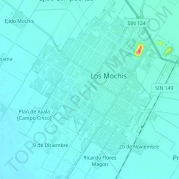
Name: Los Mochis topographic map, elevation, terrain.

Location: Los Mochis, Ahome, Sinaloa, Mexico (25.72893 -109.04634 25.83953 -108.93820)

Average elevation: 14 m

Minimum elevation: 6 m

Maximum elevation: 157 m

Other topographic maps

Click on a map to view its topography, its elevation and its terrain.

Villa de Ahome

Mexico > Sinaloa > Ahome

Average elevation: 11 m

Nuevo San Miguel

Mexico > Sinaloa > Ahome

Average elevation: 73 m

El Hecho

Mexico > Sinaloa > Ahome > El Hecho

Average elevation: 1 m

Gear up for your next adventure:

🌡️Emergency Mylar Blankets - Compact thermal protection for unexpected nights outdoors
💡Solar Camping Lamp - Eco-friendly lighting for campsites
🛰️Satellite Messenger - Emergency communication for areas with no cell service
🧥Waterproof Hiking Jacket - Protect yourself from rain and wind while hiking
🕯️Camping Lantern - Illuminates your entire campsite with high-efficiency LEDs

As an Amazon Associate, this site earns from qualifying purchases at no extra cost to you.