
Make a donation
Gear up for your next adventure:
As an Amazon Associate, this site earns from qualifying purchases at no extra cost to you.
Oberrohn topographic map
Click on the map to display elevation.
Make a donation
Gear up for your next adventure:
As an Amazon Associate, this site earns from qualifying purchases at no extra cost to you.
Oberrohn
Der Ort Oberrohn befindet sich am Westrand des Moorgrundes und am Ostrand des Frauenseer Forst. Der Ort liegt etwa vier Kilometer Luftlinie nordnordwestlich von Bad Salzungen und drei Kilometer östlich von Tiefenort. Die geographische Höhe des Ortes beträgt 276 m ü. NN.
Make a donation
Gear up for your next adventure:
As an Amazon Associate, this site earns from qualifying purchases at no extra cost to you.
About this map
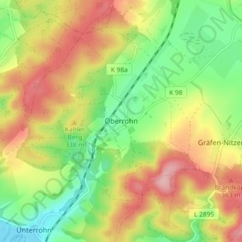
Name: Oberrohn topographic map, elevation, terrain.
Average elevation: 307 m
Minimum elevation: 236 m
Maximum elevation: 387 m
Make a donation
Gear up for your next adventure:
As an Amazon Associate, this site earns from qualifying purchases at no extra cost to you.
Other topographic maps
Click on a map to view its topography, its elevation and its terrain.
Moorgrund
Deutschland > Thüringen > Wartburgkreis > Bad Salzungen
Auf einer Gemeindefläche von 53,52 km² lebten zuletzt 3358 Einwohner (Stand: 31. Dezember 2019). Die Gemeinde befand sich auf einer Höhe von 312 m ü. NN.
Average elevation: 358 m
Ettenhausen a.d. Suhl
Deutschland > Thüringen > Wartburgkreis > Bad Salzungen > Ettenhausen a.d. Suhl
Höchster Punkt der Gemarkung ist der Hetzeberg (359,9 m ü. NN). Bemerkenswert sind auch die Berge und Hügel Sandberg (346,9 m ü. NN) und die Margarethenhöhe (307,7 m ü. NN).
Average elevation: 296 m
Make a donation
Gear up for your next adventure:
As an Amazon Associate, this site earns from qualifying purchases at no extra cost to you.