
Thank you for supporting this site ❤️
Make a donation
Make a donation
Gear up for your next adventure:
As an Amazon Associate, this site earns from qualifying purchases at no extra cost to you.
Mimétiz topographic map
Click on the map to display elevation.
Thank you for supporting this site ❤️
Make a donation
Make a donation
Gear up for your next adventure:
As an Amazon Associate, this site earns from qualifying purchases at no extra cost to you.
About this map
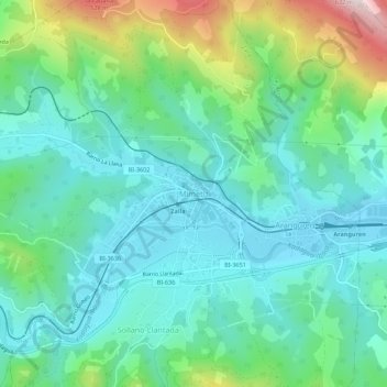
Name: Mimétiz topographic map, elevation, terrain.
Location: Mimétiz, Zalla, Vizcaya, País Vasco, 48860, España (43.19383 -3.15106 43.23383 -3.11106)
Average elevation: 210 m
Minimum elevation: 78 m
Maximum elevation: 613 m
Thank you for supporting this site ❤️
Make a donation
Make a donation
Gear up for your next adventure:
As an Amazon Associate, this site earns from qualifying purchases at no extra cost to you.